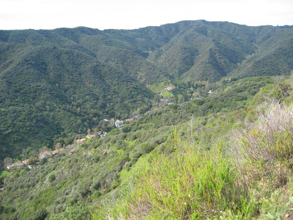
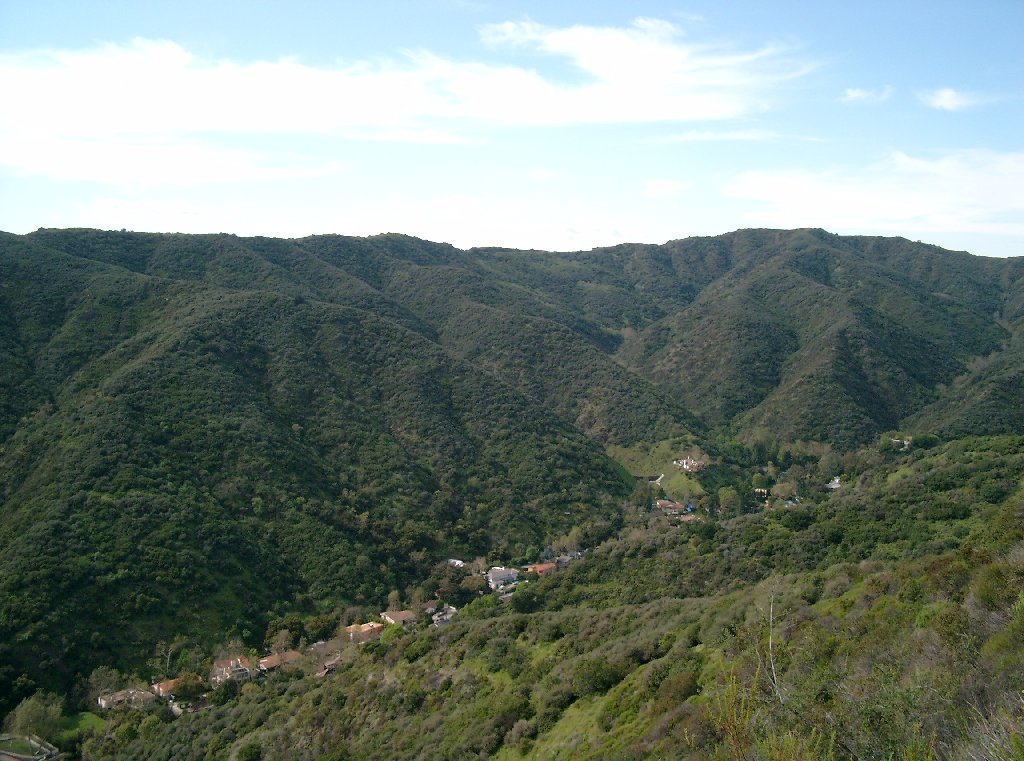
The Dangerous “Bypass Trail”
The Crown HOA’s map depicts a 2-mile long “bypass trail” that would push the existing Canyonback Trail off the ridge and onto the steep, unstable and landslide-ridden slopes above Mandeville Canyon. The long-established Mandeville Canyon residential community lies at the toe of the watershed through which the bypass trail would be graded.
Geologist Jeffrey Holt of Mountain Geology explains that the existing location of the Canyonback Trail – along the ridgeline — is a stable and safe location for a trail. Not so for the plan to realign the trail to “bypass” Canyonback Road and the ridgeline by pushing the trail onto the steep slopes above Mandeville Canyon.
The Bypass Trail Would Endanger The Upper Mandeville Community
Drainage from the proposed “bypass trail” area is concentrated through various west-trending tributary canyons. This concentrated drainage flows into the Upper Mandeville Canyon area, which lies at the base of the watershed. Flood control and storm drainage systems are located within the canyon bottom near Mandeville Canyon Road. But these flood control and storm drainage systems are subject to failure during heavy rains, especially when filled with debris. This concentrated drainage has caused flooding and mudflow problems in Upper Mandeville Canyon for the past 50 years.
The hillsides are both steep and comprised of unstable landslide remains, fill and loose residual soil. Thus, the soil on which the bypass trail would be constructed is subject to downhill creep and erosion. The remnants of several prehistoric landslides have been identified on these slopes. These potentially unstable landslide remains have been sources of mudflows and debris flows that have devastated residents of Upper Mandeville Canyon Road in the past. Construction of the bypass trail would require grading on these unstable slopes. Grading, however, would increase the already present risk of additional mudflows, debris flows, landslides, and flooding. The bypass trail would therefore risk life and property for those living at the toe of slopes along Mandeville Canyon Road.
Mandeville Canyon Is Already Subject To Severe Flood Risks
Mandeville Canyon has been designated both a “Special Flood Risk Area” and a “Very High Fire Hazard Severity Zone.” The combination of fire and flood creates an enhanced risk of hillside stability problems, explained by Councilwoman Miscikowski:
“Mandeville Canyon is unique in that rainstorms tend to bring significant amounts of debris down off the hillsides into the canyon, particularly in years following area fires. In two major rain events in the canyon over the last few decades, after wildfires in or near the canyon, huge amounts of water, mud, rocks and debris made its way down the canyon through the watercourse. For example, in a flood in the winter of 1980, significant property damage occurred, as well as loss of life. In many cases, this damage and loss was directly attributed to the fact that the watercourse, carrying a huge amount of debris, was channeled into underground pipes, pipes which could not handle the mass of material coming at once.”
The special dangers in blocking Mandeville Canyon drainage systems were again recognized by the Councilwoman in a recent series of important letters and motions intended to ensure that residents and public employees protect the integrity of the drainage system. Disaster results when drainage channels are blocked. The history of Mandeville Canyon illustrates the dangers.
When developer issued its Draft Environmental Impact Report indicating that homes would be built along the Canyonback Ridge, over Mandeville Canyon, residents were concerned that grading would destabilize the hillsides. But the Final EIR, circulated on February 22, 2005, dismissed these concerns by assuring residents that “no grading is proposed to the south of the existing water tank or on the slopes that directly drain into Mandeville Canyon.”
But the bypass trail would require grading in the area “south of the existing water tank” and “on the slopes that directly drain into Mandeville Canyon.” The bypass trail was not mentioned in the EIR.
Mandeville Canyon: A History Of Flood-Related Damages
The 1969 Flood. Mandeville Canyon was victim to a major flood in January 1969. The flooding in Southern California during that storm even was described at the time as the region’s worst flooding since 1938. Mandeville Canyon residents suffered greatly. At least a dozen homes were destroyed, more than 50 residents were evacuated, and one resident was killed.
Mandeville Canyon Road became a swirling river whose flow was estimated to exceed 15 miles per hour. In the drainage channel, the flow was an estimated 30 miles per hour. Cars covered completely in debris and water. Rivers flowed through homes at heights reaching more than 3 feet. Hundreds of National Guardsmen, police, firefighters and civilian volunteers worked to aid in the evacuation. Mandeville Canyon Road above the 2500 block was impassible to passenger vehicles for about a week, covered in a rock and mud barrier more than two feet high, with a virtual waterfall pouring over it.
Film director Robert Altman and his family, residing at 2957 MCR, were completely trapped on their property, separated from the road by a raging river they could not safely traverse. Residents at 2969 MCR saw their piano being carried across the living room in a rush of water, causing it to crash against a doorway. At the 3100 block, near what was then Robert Taylor’s Ranch, Mandeville Canyon Road was sheared off to the center divider line by the rushing water. Families beckoned passing vehicles to take them out of the Canyon.
Michael Riordan, a 41-year old father of two, was trapped inside his bedroom when mud crashed into his home at 2077 MCR. While a half-dozen firemen worked to rescue him, a second mudslide slammed into the home, bowling over the rescue team and burying Riordan. The firefighters narrowly escaped with their lives. Tragically, Riordan, the brother of former Los Angeles Mayor Richard Riordan, was suffocated in the 10 minutes it took them to dig him out.
The 1978 Mandeville Fire. The 1978 Mandeville Fire, which began on Mulholland Drive and spread through the northern borders of the Mountaingate area before spreading to Mandeville Canyon, illustrates what happens when erosion, in that case caused by fire, produces debris that is carried by heavy rains, blocking watercourses and other flood-control devices.
The 1978 Mandeville Canyon Fire made the Upper Mandeville Canyon area highly vulnerable to flooding, mudslides and debris flows. Denuded hillsides play havoc with established drainage patterns. The velocity of storm-water flow increases due to the absence of diverting vegetation, a problem that also impairs absorption. New tributaries form along the hillsides, causing water to flow where it had not before, with unpredictable results.
The vulnerability created by Mandeville Fire is akin to that created by grading the hillsides above Mandeville Canyon in an unsafe manner. As explained by Geologist Jeff Holt, grading can destabilize the hillsides, causing massive erosion, which alters the flow, blocks the existing drainage channels and flood-control devices, thereby releasing mud and flood waters along unpredictable paths – placing lives and property at risk. The risk of grading the unstable hillsides is therefore best illustrated by examining the condition of Mandeville Canyon after the 1978 Fire.
The 1979 Flood. Moderately heavy rains in March 1979, led to mudslides that caused tons of mud and rock to wash onto Mandeville Canyon Road, rendering it impassible. Four feet of debris collected on and around the road, burying mailboxes, damaging homes, and stranding residents. Newspaper accounts of this flood make the dangers clear.
The 1980 Flood. Heavy rain in February 1980 caused tremendous flooding. Mudslides covered some homes up to the eaves, buried cars, stranded residents for days, and destroyed several homes and priceless personal belongings. Again, most tragically, a Canyon resident was killed when the hillside behind her Upper Canyon home collapsed. Emergency vehicles could not get into Upper Mandeville for a week. Those who lived through the flooding will never forget it.
During the 1980 flood, waters raged through properties and even homes, destroying much in their wake as they fought their way towards Mandeville Canyon Road, which had become a river. The resident just below the Ranch built a deck and related structure across the watercourse, which ran through his back yard. Before the flood, an adult could walk in the channel and under the deck without ducking. But the rains brought down mud, trees and other debris into the natural watercourse. Debris carried by the 30-miles per hour flow in the channel began to build-up, constricting the watercourse. Eventually, branches and trees were carried to the area, but could not pass through the deck that seemed so high, so reasonably placed before. Debris built up behind the deck, damming it. Suddenly, the water streamed over the watercourse’s banks, driving an uncontrolled river into the neighbors yards and then into their homes. Waters raged through homes, destroying all in its wake as it fought through the homes and into the natural drainage path on Mandeville Canyon Road.
2005 Storms. During the January and February 2005 storms, flooding occurred in areas where the drainage system was clogged with debris or diverted by residents who failed to realize the need to keep all flood-control devices clear. A debris revetment located above 3345 Mandeville Canyon Road had been partially removed before the storms. Consequently, debris that would have been stopped by the revetment flowed into and filled the area’s drainage devices, causing raging rivers to flow through residential properties and down the street, dumping rocks and debris along the way and onto Mandeville Canyon Road, the community’s sole means of ingress and egress.
The canyon area flood channels, natural, man-made and hybrids of both, do a remarkable job of controlling heavy hillside water flows like these: video 1 & video 2. Flood-related damages caused by the 2005 storms illustrate the dangers caused by relatively minor channel blockages and failures. The proposed “bypass trail” would cause the same type of problem, but on a much larger scale. Dirt and debris from the unstable hillsides would clog the drainage paths and fill the man-made flood-control devices.
An area that is particularly vulnerable to flooding risks that would be triggered by the bypass trail is along the 3100 area. During the 1969 flood, the residents of this area were hit hard by mud and debris that clogged the man-made drainage channels above their homes. The resulting blockage brought uncontrolled rivers smashing into the homes.
Robert and Rea Westenhaver, 3156 Mandeville Canyon Road, had to climb onto their roof as debris filled the watercourse, pushing a tremendous mud-flow onto their property. Almost a foot of mud spread throughout their home, and approximately five feet of dirt was left in the parking area and courtyard outside their home. Robert Tebbe, a neighbor and relative, was almost killed when he touched a metal kitchen counter and was exposed to electrical shock. He was fortuitously saved when flood waters carried a huge log careening into him, thereby separating Mr. Tebbe from the electrical charge that would otherwise have killed him. The escaping flood waters were so strong that a detached, single-story workshop on the Westenhavers’ property was turned into matchsticks, with a file cabinet washing down to Chalon Road, about two miles away. It took more than a year to repair the Westenhavers’ property damages.
The current residents at 31XX Mandeville Canyon Road recently suffered extensive property damages during the January 2005 storms. Their home was “yellow tagged” by the City. If the bypass trail is constructed, however, it is certain that the drainage channels above their home, which did not fail during the 2005 storms, will fill with mud and debris, recreating the conditions present during the 1969 Flood. The scope of the problem would be much worse, however, because a two-mile graded trail along the unstable landslide and fill remains will bring down unprecedented quantities of mud, dirt and debris.
A resident at 32XX Mandeville Canyon Road, also lives within the watershed area that will be adversely affected by the proposed bypass trail. She too suffered flood-related damages during the January 2005 storms due to mudflow from the hillsides. The problem was controllable. But it takes little imagination to predict what would have occurred had the bypass trail been carved into the unstable hillside above. The same mudflow that deposited mud and debris on her parking area would have covered it, and threatened her home.
To envision what would happen if the bypass trail is graded into the steep and unstable slopes, just look at what happens when relatively minor blockages occur. [Large video file, may take a few minutes to download.]